undefined Cover
undefined Cover

Eidg. Forschungsanstalt für Wald, Schnee und Landschaft WSL

Tree-App - eine mobil nutzbare Webapplikation für die Waldbewirtschaftenden

Wissenschaft als Grundlage

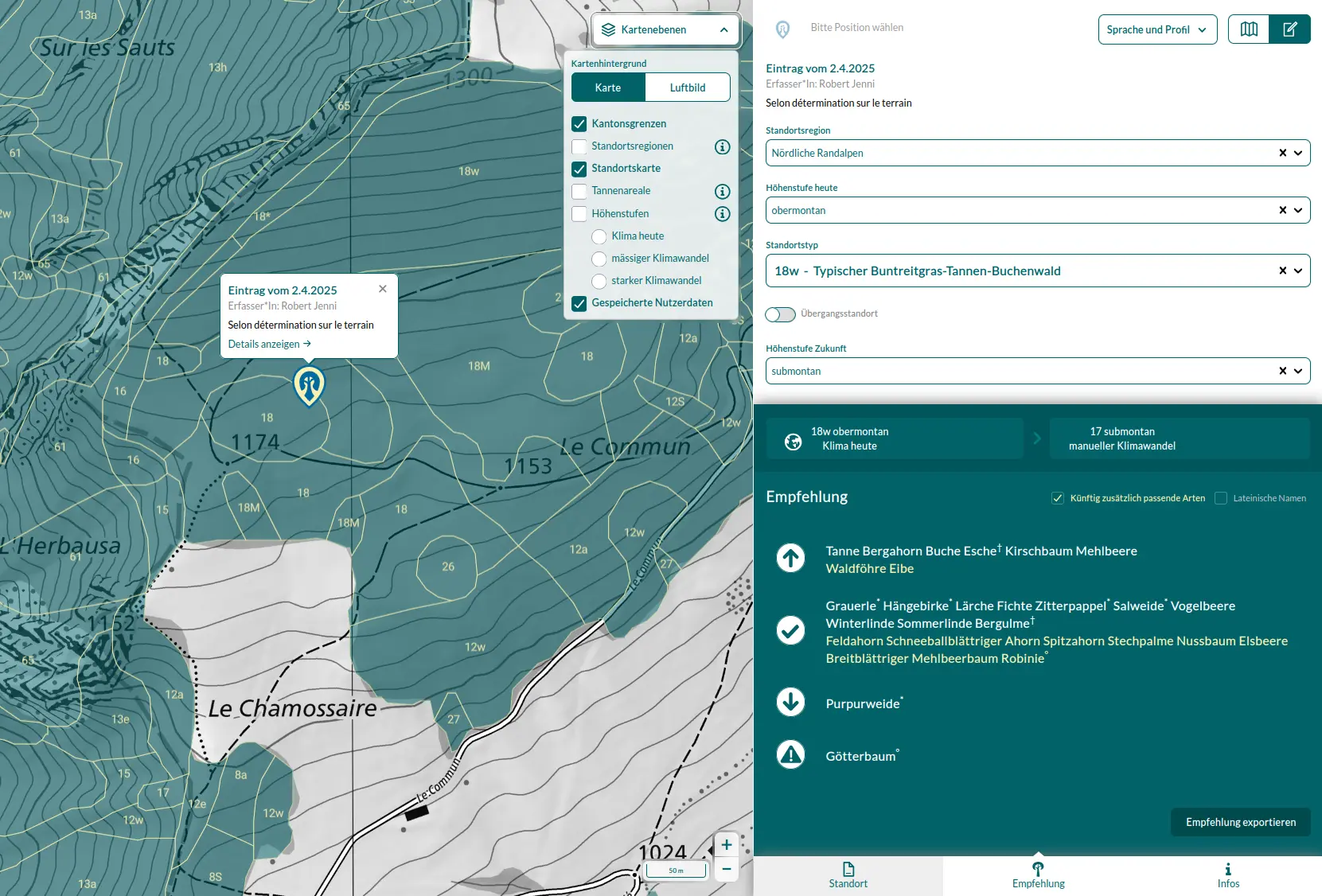
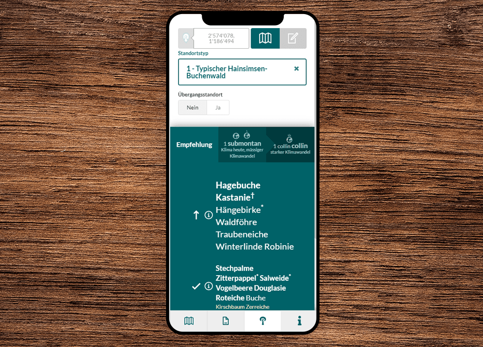
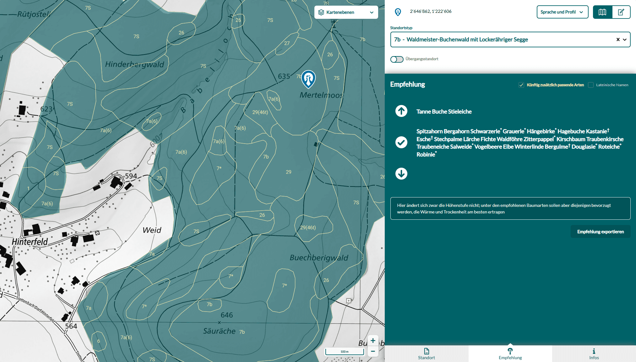
Die WSL erforscht sein vielen Jahren, wie sich der Klimawandel auf den Wald auswirkt. Mit der Tree-App macht sie dieses Wissen für die Praxis unmittelbar nutzbar. Nutzer:innen können per GPS oder Kartenwahl ihren Standort bestimmen, worauf die App klimatische Bedingungen, Höhenlage und Standorttypen analysiert. Daraus werden gestützt auf aktuelle Forschung und Zukunftsszenarien Baumartenempfehlungen abgeleitet.

Wissenschaft als Grundlage

Empfehlungen auf einen Blick

Die App klassifiziert Baumarten in drei Kategorien: empfohlen, bedingt empfohlen oder gefährdet. Dabei berücksichtigt sie neben Klimaszenarien auch Faktoren wie heimisches Vorkommen oder Krankheitsrisiken. So erhalten Waldbewirtschaftende eine fundierte, leicht verständliche Grundlage für langfristige Entscheidungen.

Empfehlungen auf einen Blick

Mobiler Einsatz in der Praxis

Weil die App speziell für den Einsatz im Feld entwickelt wurde, ist sie mobil optimiert und offlinefähig. Ihre intuitive Benutzeroberfläche und klare Kartenvisualisierung machen sie auch ausserhalb des Büros einfach nutzbar. Zusätzliche Standortdaten einzelner Kantone wie Luzern, Zürich, Freiburg oder Neuchâtel steigern die Genauigkeit noch weiter: Dort erkennt die App den Standorttyp automatisch.

Mobiler Einsatz in der Praxis

Service

xy

Timeline

laufend seit 2021

Questions?

Get in touch with us

E-Mail: info@geops.ch
Telephone: +41 61 588 05 05

More on this topic
3 min reading time › | Blog

Tree App in transition - refactoring for the future of the forest

The TreeApp has been technically modernized - with TypeScript, Next.js and an integrated database for recommendations. Improved performance, mobile usability and new functions such as sharing your own tree species recommendations round off the update.

read more
3 min reading time › | Solution

Software for the environment

Our environmental software focuses on interoperability, durability and usability.

read more
3 min reading time › | Blog

geOps at the ÖPNV-Zukunftskongress 2025

We are pleased to announce our participation in the 2nd ÖPNV-Zukunftskongress from May 5 to 7, 2025 in Freiburg im Breisgau!

read more
4 min reading time › | Blog

Managing Python Dependencies with uv

A quick look at how switching to uv improved our Python workflow, replacing tools like pip, pip-tools, and virtualenv with a faster, all-in-one solution—plus tips for migrating existing projects.

read more
2 min reading time › | Blog

mobility-toolbox-js v3

mobility-toolbox-js serves as the primary gateway for developing geospatial web applications using our geOps in-house APIs. This project has existed for years, but version 3 brings massive improvements in terms of development experience, ease of use and integration into existing applications.

read more
2 min reading time › | Blog

Faces of geOps: a portrait of Jessi

In our new interview series “Faces of geOps”, we introduce you to colleagues from the geOps team. Today: Jessi, software engineer with a career change background.

read more

Contact

geOps AG
Solothurnerstrasse 235
CH-4600 Olten

fon: +41 61 588 05 05
mail: info@geops.ch
geOps GmbH
Bismarckallee 10
D-79098 Freiburg im Breisgau

fon: +49 761 458 925 0
mail: info@geops.de
Imprint | Privacy | Terms of service